![CAD Forum - tips, tricks, discussion and utilities for AutoCAD, Inventor, Revit and other Autodesk products [www.cadforum.cz]](../common/arkance_186.png "CAD Forum - tips, tricks, discussion and utilities for AutoCAD, Inventor, Revit and other Autodesk products [www.cadforum.cz]")
CAD FORUM - TIPS & TRICKS | UTILITIES | DISCUSSION | BLOCKS | SUPPORT | HELP & ASSISTANCE

Over 1.091.000 registered users (EN+CZ).
AutoCAD tips, Inventor tips, Revit tips.
Try the new precise Engineering calculator.
New AutoCAD 2026 commands and variables.

 CAD tip # 6064:
Question
A
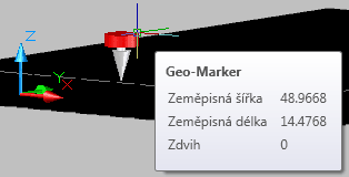
If you find a 2D arrow ("flower") or a color 3D cone in your drawing and this artifact entity cannot be selected, it is probably the "geomarker" placed to that position with the GEOGRAPHICLOCATION command:
There are three ways to specify the geo-location:
- manually enter the latitude and longitude data (e.g. from a GPS), plus the north direction
- import (load) the current position from the running Google Earth application
- import an existing KML or KMZ file in the Google Maps format (see e.g. the KML file with CAD Studio's offices - you can enter its web URL directly in the Import KML dialog)
ACAD2014ACAD2012ACAD2009ADT2009Map2009Civil2009
3.4.2008
23865×
applies to: AutoCAD 2014 · AutoCAD 2012 · AutoCAD 2009 · AutoCAD Architecture 2009 · AutoCAD Map 3D 2009 · Civil 3D 2009 ·


CADforum
Tips, tricks, utilities, help, how-tos and FAQ for AutoCAD, LT, Inventor, Revit, Map, Civil 3D, Fusion, Forma, 3ds Max and other Autodesk software (community support by ARKANCE). See About CADforum.
Copyright © 2025 | Advertise with us | Online privacy