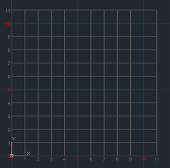
 CAD tip # 9829:
Question
 If you need to draw a rectangular orthographic or polar underlay (matrix, network, X-Y line raster) in your AutoCAD DWG drawing, you can use the free add-on utility ARKANCE DrGrid from
  Download. APPLOAD the downloaded .VLX file and type the DRGRID command. Works in any AutoCAD and since release 2024 also in the LT version.
This generator automatically creates a regular Y- and Y-axis line grid (linear or logarithmic) or a polar circular grid in a specified area. The default offset equals to the current visual grid step (F7). Optionally you can autonumber the drawn lines. Every N-th line can be emphasized. In the 3D mode, a cube (box) grid is generated.
With the option Setup you can set the grid parameters - layer, fading, color, axis labels, grid labels, polar, logarithmic...
The generated underlay grid is created in a given layer (can be set as non-printing), in a given color and linetype. The grid layer is locked and drawordered to the back of your drawing. It is cleared before any new grid is drawn.
DrGrid - visual grid as real drawing entities (objects).
Polar grid numbered, sample function from 2DPlot superimposed:

Examples of DrGrid:
You can use LISP variables to predefine grid parameters:
(setq DrGridLayer "DrGrid") ; layer
(setq DrGridColor 8) ; color
(setq DrGridMajColor 9) ; majors color
(setq DrGridTransparency 30) ; transparency
(setq DrGridLabelScale 0.5) ; relative label scale
(setq DrGridLineType "DOTTED") ; linetype
(setq DrGrid3D T) ; in 3D?
(setq DrGridPolar T) ; polar grid?
;(setq DrGridNumber T) ; numbering? (not used anymore)
(setq DrGridAxisLabels "nUmber") ; nil "nUmber" "Coordinate"
(setq DrGridLabels "nUmber") ; X/Y - nil "nUmber" "Coordinate"
(setq DrGridLogStartOrder -2) ; logarithmic starting label (order)
(setq DrGridLog T) ; logarithmic
(setq DrGridAxisLabelsBoth T) ; label also right and top axes
GRID command names: RASTR RASTER GRILLE REJILLA GRIGLIA GRADE SIATKA
![CAD Forum - tips, tricks, discussion and utilities for AutoCAD, Inventor, Revit and other Autodesk products [www.cadforum.cz] CAD Forum - tips, tricks, discussion and utilities for AutoCAD, Inventor, Revit and other Autodesk products [www.cadforum.cz]](../common/arkance_186.png)


