![CAD Forum - tips, tricks, discussion and utilities for AutoCAD, Inventor, Revit and other Autodesk products [www.cadforum.cz]](../common/arkance_186.png "CAD Forum - ARKANCE Community - tips, tricks, discussion and utilities for AutoCAD, Inventor, Revit and other Autodesk products [www.cadforum.cz]")

 What is the ARKANCE Community?
 CAD tip # 12766:
Question
This inaccuracy can then manifest itself in various ways - no touch point of spline curves found, inaccurate intersection points, curve offsets, shifted osnap points, tracking, etc. It can also manifest itself in more unusual phenomena such as not finding a fill boundary for hatches or displaying short lines with a single grip only. The more demanding geometrical transformation is performed (e.g. in Civil 3D) and the more distant are the coordinates from [0,0,0], the more significant can be the inaccuracies.

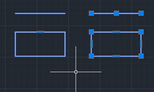
A similar problem can arise when moving objects too far in the Z-axis. Compare the grips on the objects on the left (moved to Z=9.9E+12) and on the right (same objects, Z=0):
So we recommend in case of such problems to move (_MOVE) temporarily the content of your DWG drawing as close as possible to the absolute global origin (0 0). After you complete the calculation, you can move the content back. A mere change of the UCS will not help as the calculations are internally performed in the global coordinate system (GCS).
If you see a higher risk of occurrence of such DWGs, you can prepare an automatic warning. Drag the LSP file with our utility CheckLarge.LSP (see  Download) onto the briefcase icon in the APPLOAD dialog and AutoCAD will warn you when opening a .DWG drawing with too large coordinates, which may cause complications.

