![CAD Forum - tips, tricks, discussion and utilities for AutoCAD, Inventor, Revit and other Autodesk products [www.cadforum.cz]](../common/arkance_186.png "CAD Forum - ARKANCE Community - tips, tricks, discussion and utilities for AutoCAD, Inventor, Revit and other Autodesk products [www.cadforum.cz]")
CAD FORUM - TIPS & TRICKS | UTILITIES | DISCUSSION | BLOCKS | SUPPORT | HELP & ASSISTANCE

Over 1.116.000 registered users (EN+CZ).
AutoCAD tips, Inventor tips, Revit tips, Civil tips, Fusion tips.
The new Beam calculator, Spirograph generator and Regression curves in the Converters section.
 CAD tip # 5625:
Question
A
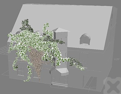
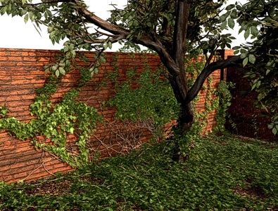
If you want to generate 3D creepers for your buildings or other objects from CAD applications, you can use the free Windows utility Ivy Generator [url verified 6/2007].
This "Ivy generator" asks for several parameters and generates a climbing plant rambling over walls and other surfaces of the loaded 3D model (building, construction, statue, etc.). It generates vegetation with stalks and leafs - including attached materials for rendering.
After loading of your 3D scene (building) double click in the scene to place the ivy root and press Grow. You can stop the growth anytime and press Birth to generate the 3D model (mesh).
ACADADTVIZmaxMayaRevit
19.6.2007
39530×


CADforum
Tips, tricks, utilities, help, how-tos and FAQ for AutoCAD, LT, Inventor, Revit, Map, Civil 3D, Fusion, Forma, 3ds Max and other Autodesk software (community support by ARKANCE). See About CADforum.
Copyright © 2026 | Advertise with us | Online privacy